![]()
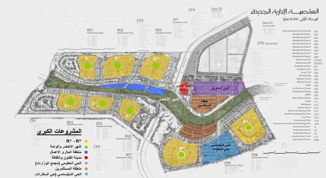
New capital map
New Capital Map
The Administrative Capital is one of the latest residential and investment cities, which was established in the Arab Republic of Egypt in recent years, on a huge area sufficient to establish many residential complexes and investment and service projects, and it was built using the latest technological means, and it is clear when you see it the great interest in the aesthetic aspects And green spaces, and the keenness to have large areas that compensate for the suffocation and congestion experienced by citizens in large cities in the Republic, and there was great keenness to use clean energy in the Administrative Capital to preserve the environment from pollution.
New Capital Map
To get to know the new administrative capital map, in the beginning we can clarify some key information about the administrative capital, the project to establish the administrative capital was announced for the first time on March 13, 2015, at the conference held in the presence of President Abdel Fattah El-Sisi, upon which a private company was established to establish the new capital under the chairmanship of Major General Ahmed Zaki Abdeen, Chairman of the company's board of directors.
The Administrative Capital is located on a vast area in the area between Ain Sokhna and the Cairo region, with an area of about 170,000 acres, and the city is also located on the border with Badr City, and near many modern residential cities that enjoy the presence of all services as well, including Madinaty, Mostakbal City, and also New Cairo City.
The Administrative Capital is considered an integrated residential city, where all the services necessary for full living are available, including schools, hospitals, mosques, commercial markets, clubs, and other services that allow an integrated life that does not lack anything.
please register, and you will be contacted for more details
The purpose of establishing the Administrative Capital
Through the New Administrative Capital map, we can say that the first phase of the Administrative Capital project has been implemented on an area of about 10,000 acres, and it was established with a capacity that attracts nearly 7 million people, and it was established for several reasons:
-
Reducing population density: The first goal of establishing the Administrative Capital was to relieve pressure on large cities, and reduce population density in them by establishing a full-service city with all service institutions and various means of transportation, and young people can live in it away from population congestion, especially in Cairo and Giza.
-
Parks and green spaces: The implementation of the Administrative Capital was carried out on vast areas, large parts of which were allocated to parks and open green spaces, to be the first green city in Egypt, in a way that allows improving living and improving the quality of life, where the per capita share of green spaces is about 15 square meters, which makes there a significant improvement in the mood and health of the population, which increases the volume of productivity at work.
-
Solar energy: It was established with the aim of creating a clean city from pollution based on renewable solar energy, as 70 of them were covered with solar panels that absorb renewable solar energy to benefit from it instead of non-renewable energy.
-
Smart City: The establishment of the Administrative Capital aims to be a smart city, in which all services are based on the use of modern and developed technological means.
-
Pedestrian City: It is considered a pedestrian city, where large areas have been allocated for cycling and walking, reducing the use of cars, and exhaust damage, which reduces the volume of pollution, as about 40% of the spaces have been allocated for this purpose.
-
Business City: The Administrative Capital was established as a center for commercial and service investments, where the business and investment sector represents a large percentage of up to 30% of the capital's business volume.
-
An integrated residential city: The Administrative Capital was originally designed to be a residential city, as an area of about 30% of the capital's area has been allocated to residential units, numbering about one and a half million housing units.
Stages of establishing the Administrative Capital
According to the plans of the company in charge of the New Administrative Capital, and after identifying the New Administrative Capital map, it was decided to establish the capital in three different stages, and these stages are as follows:
The first phase: a huge area has been allocated to carry out the construction of the first phase of the Administrative Capital, as well as it is scheduled to be 10,000 acres, but it has been expanded to become about 40,000 acres.
The second phase: an area of about 47,000 acres has been allocated for construction work.
The third and final phase came on an area of 97,000 acres.
Location of the Administrative Capital
From the New Administrative Capital map, we can clearly identify the location of the New Administrative Capital, which is located in a distinguished strategic location, both economically and geographically, as it is located in the east of Cairo between the Cairo-Suez Road and the Cairo-Ain Sokhna Road.
The Administrative Capital is located approximately 60 km from Ain Sokhna in Suez, and 60 km from Cairo.
Work has begun in the Administrative Capital, with all vigor and activity, as it was decided to transfer all ministries and government agencies, the government parliament, the headquarters of banks, as well as financial and business companies to the Administrative Capital, to become ready to become a realistically integrated capital, as was planned since the beginning of its announcement.
Arrival in New Capital
When we talk about the means of transportation available to and from the Administrative Capital, looking at the New Administrative Capital map, you can identify the roads leading to it from the Suez side by following the Suez Road directly, and then heading towards Jindali Road 2, and this road is temporary, until the development of Mohammed bin Zayed Road is completed.
If the person coming from the Fifth Settlement, he can reach the Administrative Capital from Suez Road, to the regional road, after which he will reach the capital's gate card in an estimated distance of about a quarter of an hour, after which he will reach the interior by the means of transportation available there.
Transportation in the capital has been significantly developed to facilitate connectivity between it and residential cities and nearby and surrounding neighborhoods.
The most prominent projects in the New Administrative Capital
Looking at the New Administrative Capital map, it is important to refer to one of the most important and largest service projects in it, as the implementation of the funicular train project has been started in the Administrative Capital, as one of the mega projects in it, which will greatly serve most areas in it, which facilitates the means of communication, and the train is a great boom in transportation in Egypt and the Arab world, and it is called the monorail train.
Field Marshal Tantawi station is the starting station in the skytrain line, which reaches 90 Street in the Fifth Settlement, and thus the train is scheduled to pass through 22 stations, and is expected to serve nearly one million passengers on a daily basis, which makes it the largest means of transportation in the capital.
At the end of the article, we explained the new administrative capital map, the objectives for which it was created, the location of the capital, and the stages of its construction.